
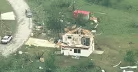
The National Weather Service issued a tornado watch for much of central and eastern Iowa until 10 p.m. Tuesday as storms threatened to erupt across the state in the afternoon and evening. A severe thunderstorm warning was also posted for parts of Hardin, Franklin, Grundy and Butler counties until 5:45 p.m. Tuesday.
Trained weather spotters located a storm capable of 60 mph winds and quarter-sized hail, a sign that the atmosphere had already turned dangerous in parts of the state. The watch covers counties including Allamakee, Black Hawk, Buchanan, Cedar, Clayton, Dubuque, Linn, Polk, Scott, Story and Winneshiek, among many others.
Storms could form as early as 2 to 4 p.m. near and just east of I-35, where the setup was expected to be most favorable first. Forecasters also warned that storms in eastern Iowa could produce very large hail, potentially around 3 inches in size, and that an intense tornado was possible if storms were able to take advantage of the ingredients available Tuesday.

The risk did not stop with the evening watch. A second area in southern Iowa was being monitored later Tuesday night for storms that could spread from south to north with heavy rain and small hail, and strong storms were possible again Wednesday with a low chance for a few storms in the morning.
The setup was being driven by a stalled front across Iowa, with active weather expected through the week. South of that boundary, highs were expected to climb into the mid-80s with high humidity, feeding the storms that were already taking shape and increasing the chance that some of them would intensify as they moved into eastern Iowa.
That is why Tuesday mattered: the state was not facing a single burst of bad weather, but a sequence of threats that could shift from afternoon storms near I-35 to overnight rounds in the south and another round Wednesday morning. For people in the watch area, the danger was immediate, and the strongest storms had the ingredients to turn severe fast.


