Storms moved into Chicago from Wisconsin on Tuesday morning, bringing the threat of 40 to 50 mph gusts, heavy rain and small hail just as commuters and air travelers were getting moving. The first round of weather also forced a ground stop at O'Hare Airport until 6:45 a.m. because of thunderstorms.
By the time the ground stop expired, departures to O'Hare were already averaging 82-minute delays. Midway was under its own ground stop from 6:40 a.m. until 8 a.m., and nine flights had been canceled at O'Hare in the past 24 hours, compared with none at Midway.
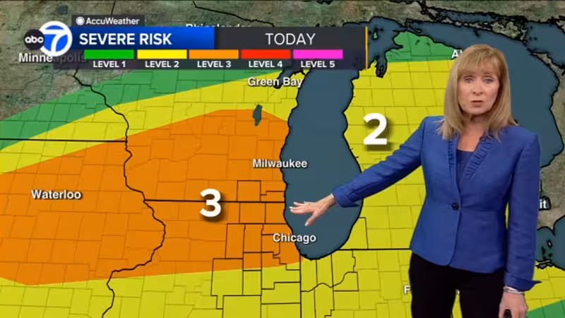
That morning disruption is only the first act. High temperatures in Chicago were expected to reach the low 80s on Tuesday, but forecasters also said severe storms could return in the afternoon and evening, with tornadoes, hail and damaging wind all possible. The risk was not limited to one burst of weather; it was part of a broader pattern that could keep the region unsettled for days.
Wednesday was expected to bring highs in the upper 70s and another chance for strong-to-severe storms. Thursday should be mostly cloudy with highs in the low 70s and a chance of rain, while Friday was forecast to turn partly sunny with highs in the mid 70s before storms return Friday night and early Saturday. Saturday was expected to be mostly cloudy with highs in the upper 60s, followed by mostly sunny weather Sunday with highs in the low to mid 50s and sunshine Monday with highs in the upper 50s.
The forecast came from Fox Chicago Meteorologist Kaitlin Cody and the National Weather Service, and it points to a stretch in which Chicago gets brief breaks between rounds of rain and thunder rather than a clean handoff to calmer spring weather. For travelers, that means the morning delays are likely not the last weather-driven disruption, especially if the afternoon and evening storms strengthen as expected.


