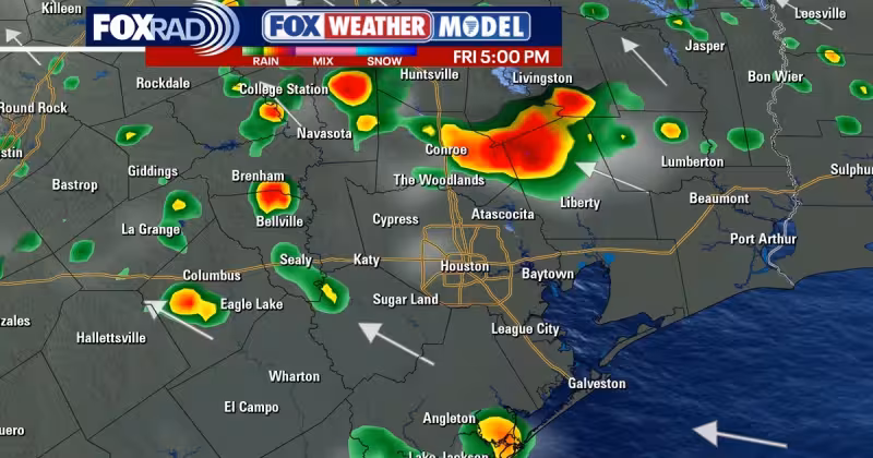
Daily downpours will be possible for the next several days in the Houston area, with Friday bringing the better chance for showers and thunderstorms. Some storms could produce brief heavier rain, but the rain is expected to stay hit and miss.
Forecaster Remeisha Shade said daily downpours will be possible for the next several days in the Houston area, and that Friday brings a stronger system and a better chance for showers and thunderstorms. The flooding threat does not appear to be a major issue at this point, and most areas will likely pick up around an inch or less through Saturday, although isolated higher amounts are possible.
The pattern matters today because it comes as Houston starts another stretch of unsettled spring weather with temperatures still running close to normal for the first part of April. Highs are expected to stay near 80 for the next few days before climbing into the middle 80s next week, when there will still be a daily chance for showers and a few storms.


Read Also: El Nino Forecast Points to Slightly Below-Average 2026 Atlantic Season
The rain outlook lands just as Colorado State University released its first 2026 hurricane season outlook on Thursday morning. The school is calling for 13 named storms, 6 hurricanes and two major hurricanes, and said the season may be slightly below average as a strong El Niño is expected to develop by the fall. Hurricane season runs from June 1st to November 30th, so the forecast is one more early marker for what could shape weather across the Gulf later this year.
For Houston, though, the immediate story is simpler: rain is coming and it may arrive in bursts, but the setup does not point to a major flood event. The bigger question is whether the area can get through the next several days with only the expected scattered showers, or whether one of the isolated heavier pockets Friday and Saturday ends up making the forecast feel a little wetter than planned.


