
The tornado watch ended tonight as storms were expected to move out of eastern counties by midnight, giving the region a dry stretch for the rest of the night. The immediate tornado threat was very low, but strong winds and hail still remained possible before the storms cleared.
Douglas and Franklin counties stayed under a Flood Warning until 12:30 AM, while Cass, Johnson and Miami counties remained under one until 4 AM Tuesday. After midnight, no storm threats were expected overnight, and Tuesday morning was forecast to start warm and dry before clouds increased later in the day.
The change is only temporary. A new round of severe weather was expected to build Tuesday afternoon into the night, with the most likely window between 6 pm and midnight. Forecasters gave that period a 60% chance of rain and severe storms, and the Storm Prediction Center placed the area under a 2/5 severe risk.

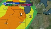
Hail and wind were listed as the primary threats Tuesday, though a few brief tornadoes could not be ruled out. Highs were expected to reach the upper 80s, with southwest gusts up to 30 mph, as storms fired up in Kansas and moved toward the area later in the day.
The pattern does not stop there. Another round of severe storms could affect the region Wednesday under a 2/5 risk, with hail and wind again the main concerns if storms develop. Thursday was expected to be dry, sunny and warm with highs in the mid 80s, before storm chances returned Friday with a possible late-day line of storms and another 2/5 risk.
Saturday morning could still bring lingering rain, and the weekend was expected to turn cooler, with highs in the upper 50s Saturday and the mid-60s Sunday. That makes the evening break after midnight useful but brief: the immediate danger is fading tonight, yet the kansas tornadoes pattern is far from over.


