An unsettled weather pattern moves in this week, bringing rounds of rain and storms mixed with dry stretches that could even include some sunshine. Temperatures will stay above average through late week, but the first real break in the pattern does not arrive until Thursday.
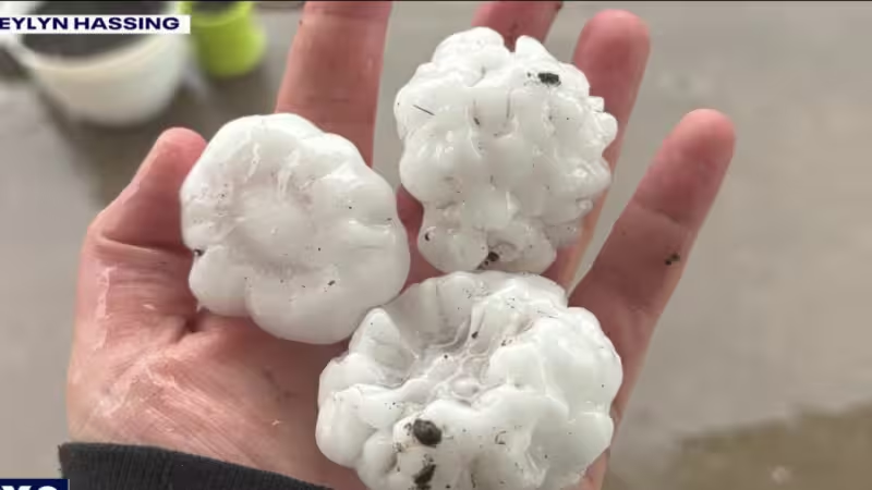
Showers and storms are expected to end Monday night into Tuesday morning from northwest to southeast, with heavy rain and small hail the main severe-weather threats. The rain could be enough to cause flooding in some communities, especially along rivers already running high after how wet the area has been through the first quarter plus of 2026.
Tuesday turns out to be another active day, with more clouds than sun and another round of showers and storms later in the day and at night. Highs should reach the low to mid-70s again, and an additional First Alert Weather Day has been declared for communities around and south of Highway 10 for Tuesday evening, when storms are expected from 4 PM to 10 PM. Large hail is the primary threat then, and the best chance for severe weather in Wisconsin will be closer to Madison and Milwaukee.


The risk does not stop there. Wednesday brings a similar chance for strong storms later in the day, with highs topping out in the mid to upper-60s and mostly cloudy skies across the area. Scattered afternoon showers and storms are possible in the southern half of the area, and the best chance for strong to severe storms will be in the southern third of the state. Strong winds and hail could develop within those storms, followed by showers and storms Wednesday night into Thursday morning.
Once the wet weather ends on Thursday, clouds may break for a bit of sun later in the day. Friday looks unsettled again, with increasing clouds and scattered afternoon and nighttime showers and storms possible. The pattern then turns cooler on Saturday, when considerable cloudiness and morning rain showers are expected, followed by the chance for rain and snow showers in the afternoon as temperatures fall from the 40s into the 30s.
By Sunday, the region is expected to be chilly and mostly cloudy, with a high in the upper 30s. For now, the bigger story is not one storm but the stretch of them: repeated rounds of rain, pockets of severe weather and a growing flooding concern for communities that have already spent much of the year running wet.


