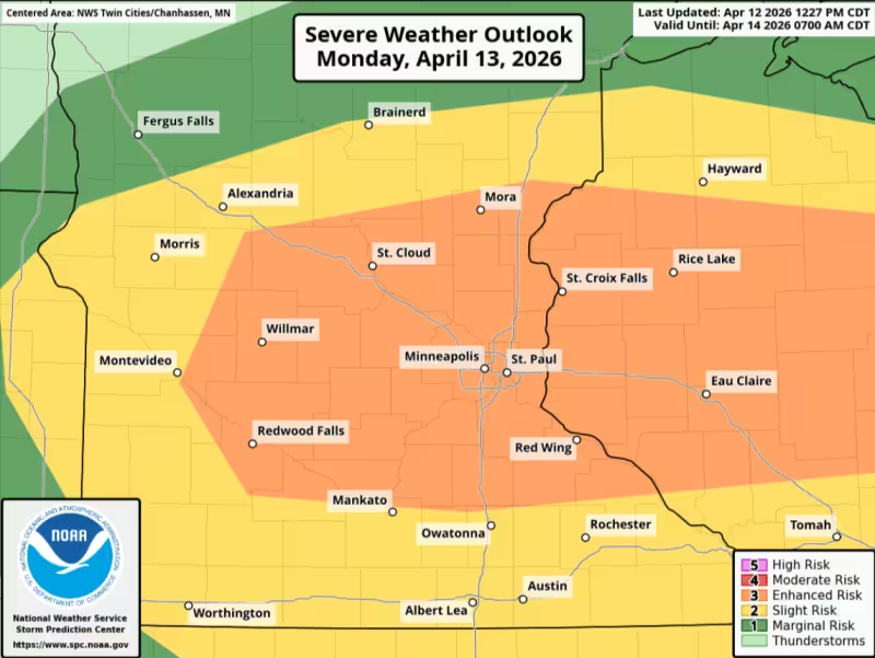
Minnesota’s Weather Authority issued a Forecast First ALERT for Monday afternoon through Monday evening as the state braces for the potential of severe storms across much of Minnesota. The Storm Prediction Center placed much of the state, including the Twin Cities metro, under an Enhanced Risk, Level 3 of 5, for severe weather.
The alert says conditions could change quickly Monday evening, with outdoor plans at risk of being disrupted if storms develop in the wrong place at the wrong time. People are being told to have multiple ways to receive warnings, move indoors quickly and seek shelter if storms approach, and review their severe weather safety plan now so they are ready to act if warnings are issued.
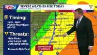
Not everyone in Minnesota will see severe weather, but the setup is broad enough that forecasters are treating it as a statewide concern rather than a localized burst of bad weather. That is why the alert matters today: the threat window begins Monday afternoon and runs through Monday evening, when timing and storm details may still be shifting.
The tension in this forecast is simple. Some communities may get through the day without seeing much at all, while others could face significant impacts if the storms line up with the Enhanced Risk area. Minnesota’s Weather Authority said to stay tuned for updates as the picture is refined, and that is the part people should not miss — the warning is already out, but the exact track and timing are still coming into focus.
For anyone with plans outside Monday evening, the prudent call is already made. The alert is not asking people to guess whether a storm will hit; it is telling them to be ready for one and to act fast if warnings are issued.


