
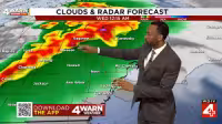
Alabama is under a First Alert Weather Day through Thursday morning as storms threaten to sweep across the WBRC viewing area from Wednesday afternoon into the overnight hours. Forecasters said storms could start developing in the northwestern counties of Marion, Lamar, Pickens, Greene, Fayette and Tuscaloosa before reaching the Birmingham metro from midafternoon through around midnight and then pushing into south and east Alabama late Wednesday evening and overnight.
The Storm Prediction Center is keeping an Enhanced Risk in place for much of the area, a sign that the setup is still favorable for stronger storms. If the storms stay somewhat isolated before growing into a line later tonight, they could produce damaging winds, large hail and an isolated tornado.
That early round matters because the evening forecast is not expected to stay broken up for long. Storms are expected to organize into a larger line later tonight, and once that happens, damaging straight-line winds become the main concern. A few tornadoes may still be possible as the system moves south and east overnight, and several inches of rain could fall in a short period in some spots.
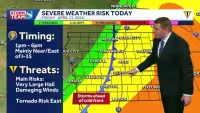
Forecasters are also watching for a second problem that does not need a tornado warning to cause trouble: heavy rainfall and localized flash flooding. The biggest concern is timing. Warnings could come overnight, when many people are asleep, and the line of storms could still be producing heavy rain into Thursday morning.
Thursday is also a First Alert Weather Day, with lingering storms and rain hazards still possible early in the day before the pattern begins to settle. The weekend should trend quieter after the midweek storm threat passes, though scattered showers and a few thunderstorms could return for Mother’s Day Sunday.
For now, the day’s answer is clear: the threat is not over after sunset, and the most dangerous part of the forecast may arrive when it is easiest to miss.


