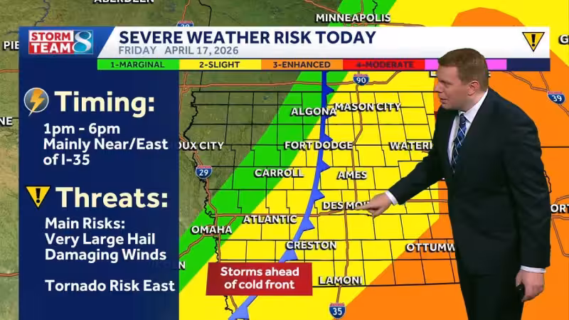
A Tornado Watch is in effect for the entire TV9 viewing area until 8 p.m. Friday as strong storms move through Iowa during the afternoon. The main window for the weather is 1 p.m. to 8 p.m., with some isolated cells possible early in the afternoon before the storms organize into a line.
Most of the TV9 viewing area is in an enhanced risk zone, with only the far northwest corner of the northwest zone in a slight risk. The risk for tornadoes is a little higher in the northeast part of the viewing area, while large hail and damaging wind are also on the table, including hailstones up to 2 inches across and gusts above 70 mph.
The setup matters because the stronger storms are expected to arrive as the cold front moves through eastern Iowa, and even after the line forms, circulations within it could still spin up a few tornadoes. The storms should move relatively quickly, which can shorten warning times and make fast updates critical.
After Friday's round of rocky weather, the forecast turns quieter. Saturday is expected to be cool, with highs in the upper 40s to mid 50s and wind gusts of 30 to 40 mph. Sunday should stay dry with lows in the upper 20s to low 30s, Monday starts cold before climbing into the 60s, and widespread 70s are likely Tuesday and Wednesday under dry conditions.
This is one more round of severe weather before an extended stretch of calmer weather, but Friday still carries the day's sharpest risk. For warnings and updates, the recommendation is to use NOAA Weather Radio, the KCRG-TV9 First Alert Weather App, KCRG.com and KCRG-TV9.


