Tuesday is shaping up to be the wettest day of the week in the Brazos Valley, with widespread showers and a few thunderstorms expected as an upper-level low moves directly overhead. Gulf moisture is continuing to feed the system, and while severe weather is not expected, forecasters say low-lying areas and places with poor drainage could see minor isolated flooding.
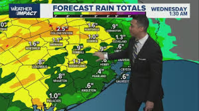
Monday stayed mostly under clouds, with a few light showers scattered through the day and more showers expected to linger into Monday evening. The main change comes Tuesday, when the wet weather really moves in and rain gear is recommended for both the morning and evening commutes. Totals could range from about a quarter inch to 1.5 inches across the region, with isolated higher amounts possible in stronger storms.


The rain is tied to Gulf moisture and the upper-level low moving across the state through midweek, a setup that keeps the Brazos Valley in a damp pattern without pointing to widespread dangerous weather. The forecast says the main impacts should stay north of the Brazos Valley, but the area itself still faces enough rain to create travel headaches and brief flooding in the usual trouble spots.
Another disturbance is expected on Wednesday, bringing a 40-50% chance for rain and a few storms, and conditions should gradually improve toward the weekend. Another system could still send showers through Friday or Saturday, though rain chances are expected to become more isolated as the week goes on. Temperatures are expected to stay in the 70s through the week before climbing back into the mid-80s by Friday, with humidity increasing late in the week.
For people in the Brazos Valley, the message is simple: Tuesday is the day to watch. The weather will stay unsettled through midweek, but the more disruptive stretch should be brief, with the biggest concern centered on repeated rain, not severe storms.


