Oklahoma was bracing Monday for a multi-day stretch of severe weather that meteorologists said could become one of the most active patterns of the season, with damaging winds, large hail and tornadoes possible on multiple days. Storm trackers were already reporting rotating storms across western Oklahoma as the first round began to take shape.
Chief Meteorologist David Payne said severe weather was starting to ramp up south of the Red River, with storms forming in Texas expected to move northeast into southwest Oklahoma and more storms likely to develop along a dryline over the next several hours. A tracker near I-40 west of Elk City reported broad, mid-level rotation in one storm, while other storms in southern Oklahoma were producing hail and heavy rain.

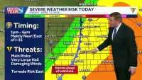
By Monday evening, conditions were expected to become more favorable for tornado development, with the most active period forecast between 7 p.m. and 10 p.m. as storms moved northeast toward central Oklahoma. One storm was already producing hail larger than golf balls and was expected to move through Tillman County and into Grandfield, Randlett, Temple and Elgin through late afternoon. A Tornado Watch remained in effect until 11:00 p.m. for 29 counties, including Oklahoma, Canadian, Cleveland, Comanche, Caddo, Payne, Pottawatomie and Tillman.
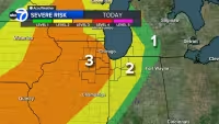
Forecasters at the Bob Mills Weather Center said the setup could be among the most active weather patterns so far this season, and they warned that the threat would not end with Monday night. Severe weather was expected to ramp up again Tuesday afternoon as warm, humid air, strong south winds and increasing jet stream energy combined to support scattered severe thunderstorms, including storms capable of producing very large hail. Another round was expected Wednesday, and additional storm chances could return late Friday as a cold front moved through.
The pattern was unfolding against a backdrop of heat, dryness and wind that kept a heightened wildfire risk in place across western Oklahoma even as storms moved in. Most of the rotation seen so far had stayed above ground level, but meteorologists said the setup was expected to improve for tornado development later Monday night. For residents in the path, the answer was already clear: the main danger was not a single storm, but a run of severe weather that could keep Oklahoma under threat through midweek and return again before the week is out.


