Today brings a mix of clouds and some sunshine, and most areas should stay dry. A stray shower or two cannot be ruled out, but the bigger change is that highs are returning to the 70s for most of the region.
That brief taste of milder air is expected to hold into Tuesday, when high pressure continues to control the weather and brings more sunshine and warmer temperatures. By Wednesday, highs are set to climb back to and above average, setting up the next chance for a change in the pattern.
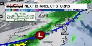
A surface low is approaching the area midweek, and if it tracks into the region, there could be a decent chance for scattered showers and storms later Wednesday into Thursday. For now, the setup leaves the region dry enough to keep the bigger concern in place: the drought monitor still shows a dry pattern, with severe drought covering almost the entire viewing area and extreme drought moving into the eastern part of the region.
The numbers underscore how hard it would be to reverse that grip. The wettest May on record, back in 1898, produced 9.08 inches of rain, and even that amount would not be enough to wipe out the current major drought. So while the next few days bring a return of sunshine and a better shot at seasonable warmth, the rain threat later this week may offer only limited relief unless the system lines up just right.
That is the central question heading into Wednesday and Thursday: whether the approaching low can deliver anything more than scattered rain. Based on the current forecast, most places stay dry through Tuesday, but the region will need a more sustained wet stretch than this one system can guarantee to make real progress against the drought.


