
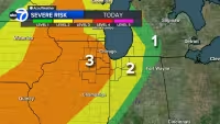
Missouri is heading into a long stretch of dangerous weather Sunday night, with a Tornado Watch in Henry County until 11 pm and a Severe Thunderstorm Watch in Johnson, Lafayette, Pettis and Saline counties until 9 pm.
The watches are tied to the first of three rounds of severe storms expected over the next 24 hours. The first line is moving east through Missouri counties until around 9 pm and could bring strong winds, hail and isolated tornado spin-ups, with wind damage the main concern as the storms push from western to central Missouri.
The heaviest weather is not expected to stop there. A second round is likely near and after midnight and could pack winds up to 75 mph, large hail of 2 inches or greater and tornadoes. A Flood Watch is also in place until 7 pm on Monday, with rain totals of over 2 inches possible in isolated areas and flash flooding a concern during the prolonged period of storms.

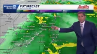
For Monday morning, a First Warn Weather Day remains in effect. The main threats from 4 AM to 9 AM are flooding and a continued chance for severe storms, with a potential storm line timed to move through during that window. By the afternoon, the bulk of the rain and severe weather is expected to clear out, though a few isolated thunderstorms could still pop up north of I-70.
Temperatures Monday are expected to reach the upper 70s, with gusts up to 30 mph. After that, the pattern settles down through the rest of the week, with Thursday the only day carrying a rain chance, and that forecast stands at 30 percent.
The answer to whether the worst of the weather will be confined to Sunday night is no: the threat stretches into Monday morning, with flooding and severe storms both still in play before conditions begin to improve later in the day.


