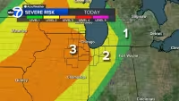
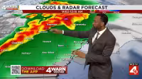
Severe storms rolled toward north central Wisconsin on Friday afternoon, with a tornado watch in effect for most of central Wisconsin until 8 p.m. and a severe thunderstorm watch running until 5 p.m. The third and final round of severe weather this week was expected to bring hail, strong wind gusts and a few tornadoes.
Those storms also carried the threat of heavy rain at a time when several counties were already under a Flood Watch because rivers were flooding. Some places could pick up 1-2+ inches of rain by very late Friday, while wind gusts of 25-35 MPH were expected ahead of the storms as temperatures climbed into the low to mid-70s across most of the area and the upper-70s farther south.
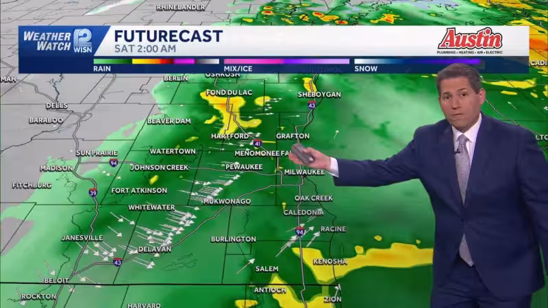
The timing matters because the weather changes fast after dark. A cold front was expected to sweep through north central Wisconsin after the storms, sending temperatures close to freezing by Saturday morning and leaving open the possibility of a light wintry mix to snow in some communities. Highs on Saturday were expected to top out in the upper-30s and low-40s, with wind gusts reaching 35-40 MPH, a stark turn after Friday’s mild afternoon.
Sunday should stay blustery, though less volatile, with gusts around 20-25 MPH and highs in the low to mid-40s. Precipitation was unlikely from Sunday onward through most of next week, and highs were expected to rebound into the upper-60s and low-70s by Tuesday next week. Rivers south of Highway 29 were expected to mainly crest over the next few days before levels drop heading into next week.
The hard part for Wisconsin is that the storm risk and the flood risk are arriving together, then giving way to a weekend that feels far more like late winter than late spring. By Tuesday next week, the region is set to be back near seasonable warmth, but first comes the last severe round, the flooding rain and a Saturday morning cold snap that could leave some communities staring at frost and even a little snow.


