A tornado watch was in effect until 11 p.m. Tuesday for 39 counties in Oklahoma, including the Oklahoma City metro, as severe thunderstorm warnings spread across the state and the risk of tornadoes remained low.
The storm threat was shifting east and weakening, but it was not gone. The severe storm risk was decreasing rapidly this evening across Oklahoma, though an isolated threat for strong wind remained and parts of the state were still under warning for damaging gusts and hail.
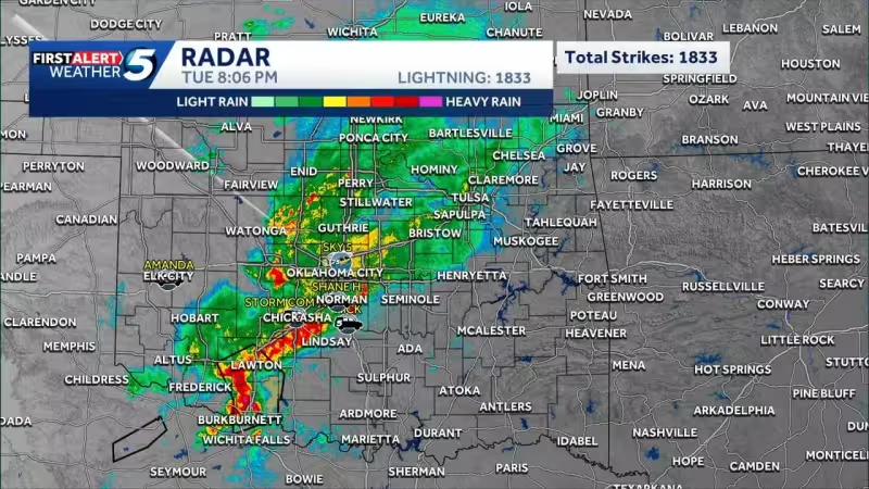
In southern and central Oklahoma, a severe thunderstorm warning covered Garvin, Grady, Stephens, Carter, Cleveland and McClain counties until 9:45 p.m. The storm, located along a line from Rush Springs to northeast of Comanche, could bring 60 mph wind gusts as it moved northeast at 45 mph. Another severe thunderstorm warning remained in effect until 9:15 p.m. for Comanche, Grady, Caddo, Stephens and Cotton counties.
Farther south, a storm near Chattanooga, Geronimo and Lawton was warned until 8:30 p.m. and could produce 70 mph winds and small hail. Another warning was issued for a storm along a line stretching north of Foss to northwest of Willow, with ping pong ball-sized hail and 60 mph wind possible. Areas near Canute and Strafford were expected to see the largest hail chances.
Warnings also covered Washita, Custer, Greer and Beckham counties until 6:30 p.m., and the tornado watch remained in place there as well. Southern Oklahoma, including Stephens and Cotton counties, was also under a severe thunderstorm warning until 6:30 p.m. The state’s storm threat had been upgraded earlier to a level 3 enhanced risk for part of Oklahoma, including the Oklahoma City metro, with that zone stretching from southwestern through central and into north-central Oklahoma.
The setup had been complicated by showers earlier Tuesday, which Damon Lane described as “messy.” That moisture did not eliminate the threat; it left enough instability for storms that could still produce twisters and large hail before the evening ends. In Beckham County, all eastbound lanes of Interstate 40 were closed at Merritt Road near Elk City because of a crash, adding another disruption in a state already dealing with severe weather.
For now, the answer to the day’s big question is straightforward: the tornado threat stayed low, but Oklahoma still had a real severe weather problem on its hands Tuesday night, with damaging wind and hail the main concerns until the warnings expired.


