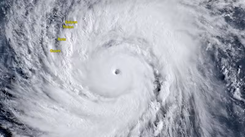
Tropical Cyclone Sinlaku reached Category 5 strength on April 12 and is now forecast to pass very near Saipan and Tinian on Tuesday morning U.S. Eastern time, putting the U.S. Northern Mariana Islands in the path of one of the fiercest storms of 2026. The Joint Typhoon Warning Center said the system was still packing 175 mph winds at 11 a.m. EDT Saturday before later upgrading its peak to 185 mph.
The storm’s rapid rise has been extraordinary even by western Pacific standards. Sinlaku likely peaked at 5 p.m. EDT Sunday with 180 mph winds, and the Japan Meteorological Agency estimated its central pressure at 905 MB and its winds at 135 mph using a 10-minute average at 21Z Sunday. By that point, it had strengthened by 75 mph in the previous 24 hours, a burst powered by low wind shear of 5 to 10 knots and sea surface temperatures of 28 to 29 degrees Celsius, or 82 to 84 degrees Fahrenheit.
Sinlaku’s name was contributed by the Federated States of Micronesia and refers to the goddess of nature and breadfruit of Kosrae Island. The storm formed over warm Pacific waters southeast of Guam that extended to great depth, with an ocean heat content of 125 to 150 kilojoules per square centimeter, giving it an ideal fuel source as it approached the islands.

The Joint Typhoon Warning Center said Sinlaku would slowly weaken on Monday as it neared the U.S. Northern Mariana Islands, but the forecast track still puts it close enough to threaten a direct hit on the region’s two most exposed islands. Saipan, with a population of 43,000, and nearby Tinian, home to 2,000 people, are the places forecasters said would feel the storm most closely as it moves through Tuesday morning U.S. EDT.
The tension now is not whether Sinlaku is weakening, but whether it weakens fast enough before reaching a populated island chain. The list of Category 5 storms from January through April is typically short, and this one has already joined it as only the second Category 5 tropical cyclone of 2026.