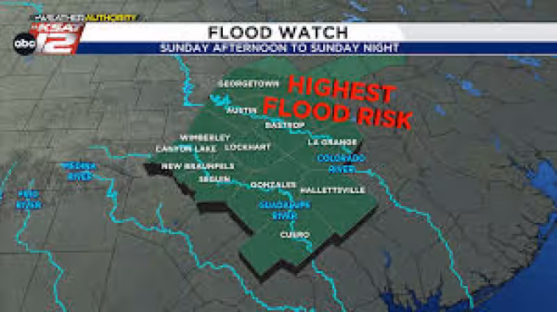
San Antonio started damp on Sunday, and forecasters said storms could redevelop later in the day as rain chances held between 40% and 60% through Sunday afternoon and evening. The threat was not locked in for every corner of the city, but the strongest concern centered east of San Antonio, where flooding rains could develop near the Guadalupe or Colorado Rivers and along I-35 and I-10.
If storms build again, they could bring hail, damaging winds and heavy rainfall, with a flash flood warning meaning rushing water could cross roadways. Sarah Spivey summed up the advice plainly: “TURN AROUND, DON’T DROWN.” The warning mattered today because the wet start could give way to a more dangerous afternoon and evening, when even a few pockets of heavier rain could create trouble fast.
The flooding concern comes after a damp morning and against a broader forecast that turns less active next week. A storm or two could still show up on Wednesday, but the pattern was expected to calm down after that, setting up Fiesta with quiet weather and temperatures near 90 degrees when it begins.


Read Also: Mcallen Tx heritage center kicks off 2026 Chuckwagon Dinner fundraiser
That slower stretch does not last the whole first weekend of Fiesta. A cold front was expected to move through on Saturday, bringing a small chance for rain, and then a cooler, pleasant Sunday. For people planning around weather san antonio, the message is clear: Sunday carries the bigger risk, while next week and the start of Fiesta look mostly manageable, with the real exception of Saturday’s front and the lingering chance for a storm or two on Wednesday.
April 12 is the day the weather story splits in two for San Antonio — a damp, stormy afternoon for some areas, then a calmer run-up to Fiesta after the front passes. The question for drivers and anyone near low-lying roads is not whether the city sees a citywide washout, but where the heavier rain sets up and how quickly it makes roads unsafe.


